Author Topic: Henry Coe State Park March 21, 2015  (Read 138438 times)

Skyline35

  • Mudders
  • **
  • Posts: 109
Henry Coe State Park March 21, 2015
« on: March 24, 2015, 12:16:12 PM »
Let's begin this ride report with the road to Coe. It first began to washout in 2010. Even though there hasn't been much rain lately, some more of the road recently slipped into Coyote Creek:


.

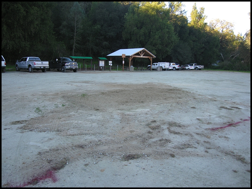
Next the Hunting Hollow parking lot....the ramada and signboard that were in the middle of the lot are completely gone with new stuff on the cold side of the lot:


.

Over the last few weeks I've been doing some light brushing of the PCT but today I wanted to just do a nice long ride out to the top of Bear Mountain. In the lot I had a nice chat with Mark H who rode out to Mustang Peak (on his third (!) replacement Tallboy frame). Early in the ride I talked with Chris K—recovering from back surgery in August 2014—and met his brother Jason who is recovering from an accident with a car (broken leg).

The Anza/Jackson/Elderberry climb began the day. At Elderberry a volunteer group was beginning a project to remove some ruts. One of my earliest Coe trailwork days was on that exact spot (October 2007). Someone invited me to join the workcrew and I said they were fixing what I did years ago!

.

Here's a Horned Lizard that I spotted on White Tank Spring Trail:


.

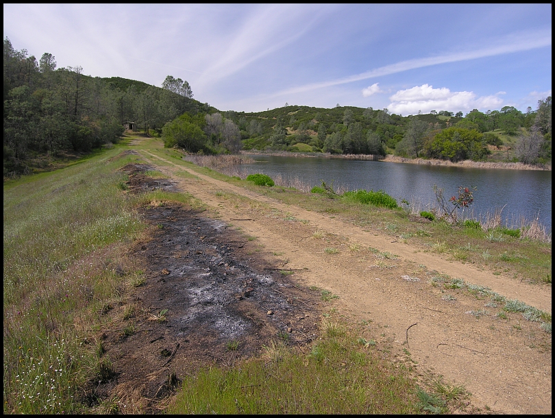
My trip up the PCT went nicely. In no time I was at Mississippi Lake. There were some fresh burn spots on the dam:


.

Likely those were debris piles from this work:

[youtube=640,480]G3D78n3VHdo[/youtube]

.

I say recent because a few days before I saw a crew burning the 2 year old piles of reeds on Hoover airstrip:
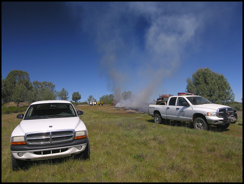


I expect the same crew hit Mississippi Lake.

.

Going around the east side of the lake, I found the road completely blocked by this fallen tree:


.

Extra bad with a bike because all those little branches get caught in the spokes and stuff. It turned out to be more difficult than it looks to do anything with it. Too heavy to move. A bunch of branches had to be cut just to get to the trunk before attempting to cut that and when I did, it pinched the saw so I gave up. Didn't want to burn a lot of time here but even so this stop was 30 minutes. In the end, there was at least a hole to squeeze through:


It looks like it might have made more sense to work on the right but like I said, I hoped to cut the trunk.

.

While I'm doing that, Ranger Jenn makes a routing patrol stop at the ramada on the opposite side of the lake, roughly 1:45pm, and drives off. I ride up the Bear Spring Trail to the top of Bear Mountain. I like it, nothing steep or technical; it's overgrown but you can get through (with a lots of scratches on your arms and legs).

Arrival at Bear Mtn is 2:37pm. I didn't know it but the 2015 Coe Monstercross ride was today and they had been at this spot at 1pm. Their day was about to turn bad because one of the riders wiped-out descending the very steep fireroad down to Coyote Creek. They got him up and going, and changed their route to go directly to Coe HQ. Jenn was going their direction and came upon the group. She assessed the rider's condition:


photo Patrick

.

…and decided he should go to the hospital (he had hit his head). A helicopter was called:

http://www.firescan.net/cgi-bin/playtime.cgi?ch=2&hr=14&mi=08&s=18&m=3&d=21&y=2015&t=14400&rate=56&z=playback

(It takes a couple minutes to get to it.) Jenn drove him to the landing spot somewhere on Manzanita Point Road. He was examined and released from the hospital that evening.

For the complete story of their ride, see Patrick's photoset.

Patrick's track.

Track for the guy that crashed (Ryan).

And Marco's track.  The next day Marco broke his ribs crashing on the Soquel Demo Flow Trail. Tough weekend!

.

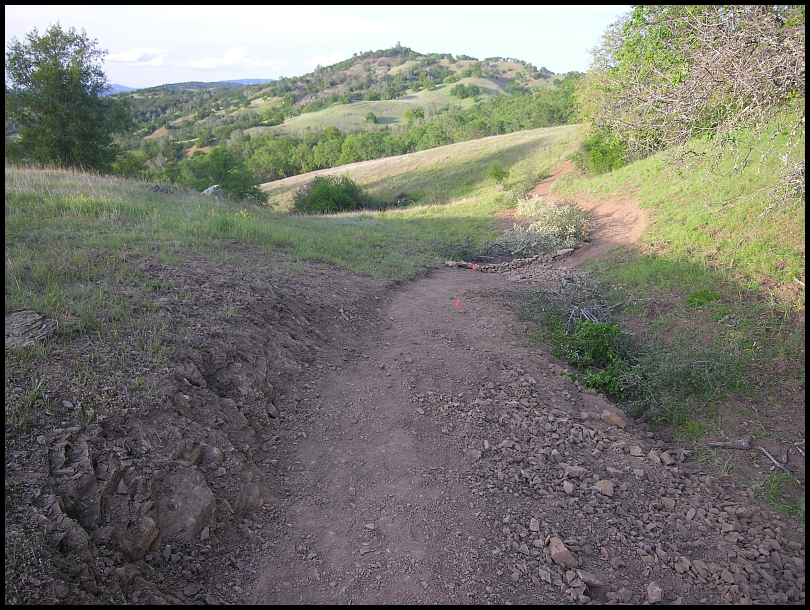
My route was in a completely different direction so I missed all this while it was happening. The return trip was uneventful, I even had time to checkout the Elderberry work which I thought was a nice design:


.

Ha, while there I noticed that there were 12 eyes looking at me:
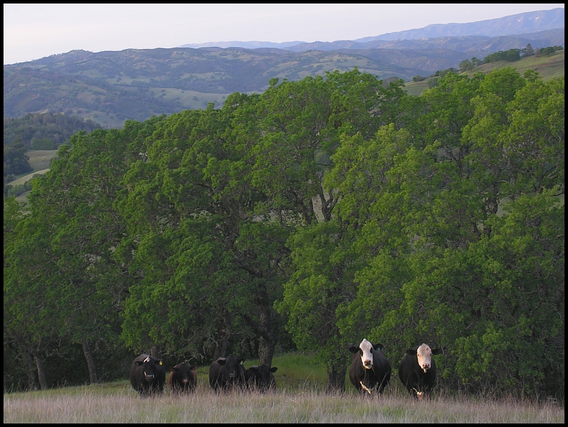


Those are the 6 strays that have been in the south end of the Park since last summer.

.

Start at Hunting Hollow 9:07am » Gilroy Hot Springs Road » Coyote Creek entrance » Coit Road » Anza Trail » Jackson Trail » Elderberry Spring Trail » Rock Tower Trail » Domino Pond Trail » Wasno Road » Coit Road » Willow Ridge Road » White Tank Spring Road » White Tank Spring Trail » Rose Dam Trail » Pacheco Creek Trail » Willow Ridge Road » Mississippi Lake Perimeter Road (East side) » Bear Spring Trail East Alternative » Bear Mountain Road » Bear Mountain » Bear Mountain Road » Bear Spring Trail East Alternative » Mississippi Lake Perimeter Road (West side) » Willow Ridge Road » Pacheco Ridge Road » Heritage Trail » Pacheco Creek Trail » Pacheco Camp » Coit Road » Live Oak Spring Trail (upper) » Wagon Road » Wasno Road » Jackson Road » Jackson Trail » Anza Trail » Coit Road » Coyote Creek gate » Gilroy Hot Springs Road » Hunting Hollow parking 7:07pm 45.70/7:43/10:00l6,952'

Gilroy:


Cordoza Ridge:


mudworm

  • Head Mistress
  • *
  • Posts: 1725
    • http://www.mxi2000.net
Re: Henry Coe State Park March 21, 2015
« Reply #1 on: March 25, 2015, 10:17:53 AM »
six wild cows!  :D
Inch by inch, I will get there.

Skyline35

  • Mudders
  • **
  • Posts: 109
Henry Coe State Park March 28, 2015
« Reply #2 on: April 03, 2015, 05:41:07 PM »
six wild cows!  :D
...outstanding in their field.

So I have a photo above of State Park crews burning the old piles of reeds left over from a lake de-reeding project 2 years ago. On this ride I rode through this area and ha, they only did the piles on the right:


I was puzzled; they had the crew there, why not finish? Maybe a afternoon wind came in or something. That they left the water tank trailer give hope that they will be back to finish up.

.

People have been asking me where are my Spring flower photos? Well it hasn't been a good year for that but here, I slowed down a little and took a shot of some poppies as I rolled by:


You're welcome.


Start at Hunting Hollow 9am » Gilroy Hot Springs Road » Coyote Creek entrance » Coit Road » Anza Trail » Jackson Trail » Elderberry Spring Trail » Rock Tower Trail » Domino Pond Trail » Wasno Road » Coit Road » Willow Ridge Road » Hoover Lake Trail » Hoover Lake » Hoover Airstrip » White Tank Spring Trail » Rose Dam Trail » Pacheco Creek Trail » Willow Ridge Road » Mississippi Lake Perimeter Road (West side) » Bear Spring Trail East Alternative » Bear Mountain Road » Bear Mountain » Bear Mountain Road » Bear Spring Trail East Alternative » Mississippi Lake Perimeter Road (West side) » Willow Ridge Road » Pacheco Ridge Road » Laurel Trail » Pacheco Creek Trail » Pacheco Camp » Coit Road » Live Oak Spring Trail (upper) » Wagon Road » Wasno Road » Tule Pond Trail » Grizzly Gulch Trail (Big crash! One of my top 10.) » Coit Road » Coyote Creek gate » Gilroy Hot Springs Road » Hunting Hollow parking 6:41pm (sunset 7:25pm). 44.70/7:40/9:40/6,711'


Gilroy:


Cordoza Ridge:


mynameismud

  • unworthy
  • Posts: 5978
    • Mudncrud
Re: Henry Coe State Park March 21, 2015
« Reply #3 on: April 06, 2015, 07:15:49 PM »
dig the gopher snake!

How do  you like the Thunder Burts?
Here's to sweat in your eye

Skyline35

  • Mudders
  • **
  • Posts: 109
Re: Henry Coe State Park March 21, 2015
« Reply #4 on: April 07, 2015, 07:51:09 AM »
How do  you like the Thunder Burts?
I like a fast rolling rear tire such as the Kenda Small Block Eight (not available in 27.5"). The Thunder Burt is like a SB8; very low knobs but it has bigger side knobs (yay). I have the snakeskin version so the sidewalls will be more durable and it easily set-up tubeless. Claimed 480g but mine is actually 533g, still light for a non-paper-thin-sidewall tire. Lastly, it is only 27 1/8" tall so the effective gearing is lower. Only a couple rides on it so far; I'm liking it.

mynameismud

  • unworthy
  • Posts: 5978
    • Mudncrud
Re: Henry Coe State Park March 21, 2015
« Reply #5 on: April 07, 2015, 09:22:08 AM »
good feedback thanks.  Will have to see if they have a 29 version.
Here's to sweat in your eye

Skyline35

  • Mudders
  • **
  • Posts: 109
Henry Coe State Park April 18, 2015
« Reply #6 on: April 21, 2015, 07:58:52 PM »
dig the gopher snake!

This one was mad at me and hissing like crazy:


I couldn't recall a gopher snake behaving like that. Coincidentally Bruce B filmed this angry Gopher snake on the same day in Santa Cruz: https://instagram.com/p/1oY9f2P22q/

.

That was from April 18 on my first trip back to Coe after my big wipe-out 3 weeks ago, a few more random photos from that ride...

.

It's April and this should be much, much greener:


.

More...


.

Chaparral Clematis;


.

End of the day and it's all downhill from here...


Start at Hunting Hollow 8:37am » Gilroy Hot Springs Road » Coyote Creek entrance » Coit Road » Anza Trail » Jackson Trail » Elderberry Spring Trail » Rock Tower Trail » Domino Pond Trail » Wasno Road » Coit Road » Willow Ridge Road » White Tank Spring Road » White Tank Spring Trail » Rose Dam Trail » Pacheco Creek Trail » Willow Ridge Road » Mississippi Queen overlook » Willow Ridge Road » Pacheco Ridge Road » Laurel Trail » Pacheco Creek Trail » Pacheco Camp » Coit Road » Pacheco Ridge Road » Phoneline Trail » Coit Road » Pacheco Ridge Road » Ridge Trail » Pacheco Creek Trail » Pacheco Camp » Coit Road » Live Oak Spring Trail (upper) » Wagon Road » Wasno Road » Jackson Road » Jackson Trail » Anza Trail » Coit Road » Coyote Creek gate » Gilroy Hot Springs Road » Hunting Hollow parking 6:39pm (sunset 7:44pm) 41.30/7:18/10:02/7,004'


Gilroy:


Cordoza Ridge:


mynameismud

  • unworthy
  • Posts: 5978
    • Mudncrud
Re: Henry Coe State Park March 21, 2015
« Reply #7 on: April 22, 2015, 06:49:24 AM »
Wild.  I had no idea that gopher snakes hissed like that.

I also had no idea you crashed.  Keep the rubber side down.
Here's to sweat in your eye

clink

  • Meanderthal
  • ****
  • Posts: 4078
Re: Henry Coe State Park March 21, 2015
« Reply #8 on: April 22, 2015, 09:23:14 AM »
Awesome pics. Biking is scary.
Causing trouble when not climbing.

Skyline35

  • Mudders
  • **
  • Posts: 109
Henry Coe State Park March 23, 2015
« Reply #9 on: April 23, 2015, 06:43:06 AM »
I also had no idea you crashed.  Keep the rubber side down.
I caught a rut with my front tire while descending Grizzly Gulch. Big bruise on my hip, moderate bruise on my ribs, and my elbow was shredded.

Yesterday I went out to upper White Tank Spring Trail and spent ~4 hours pruining back the foliage. Cool temps, foggy morning and partly cloudy afternoon. Drizzle in the morning soaked the tall trailside grass and before long my shoes were soaked!


Start at Hunting Hollow 8:50am » Gilroy Hot Springs Road » Coyote Creek entrance » Coit Road » Anza Trail » Jackson Trail » Elderberry Spring Trail » Rock Tower Trail » Domino Pond Trail » Wasno Road » Coit Road » Willow Ridge Road » White Tank Spring Road » White Tank Spring Trail » Ad hoc trailwork on upper White Tank Spring Trail » White Tank Spring Trail » Willow Ridge Road » Crest Road » Willson Field Hill Radio Tower » Crest Road » Wagon Road » Wasno Road » Jackson Road » Jackson Trail » Anza Trail » Coit Road » Coyote Creek gate » Gilroy Hot Springs Road » Hunting Hollow parking 6pm (sunset 7:47pm) 27/4:21/9:08/4,518'


Gilroy:


Cordoza Ridge:


mynameismud

  • unworthy
  • Posts: 5978
    • Mudncrud
Re: Henry Coe State Park March 21, 2015
« Reply #10 on: April 23, 2015, 01:56:13 PM »
Heal up and thank you for the trail work.  Will try and get a ride in there when I get back from Washington.
Here's to sweat in your eye